
AI ROAD MONITORING · 26 OCTOBER 2026
AI Pothole Patrol: MetaSpatial’s role in the RMIT–RACV Victorian trial
From perception hardware to scalable spatial intelligence.
“RoughSense demonstrates the value of bringing industry expertise and university research together to address real-world road safety challenges.”

MetaSpatial is an industry technology contributor to the RMIT-led Pothole Patrol pilot supported by RACV. The Victorian project demonstrates how routine vehicle journeys can become a source of road-condition evidence.
Watch: Pothole Patrol in action
Two months. A clearer picture of road condition.
21 August–21 October 2026 · Mornington Peninsula, Victoria.
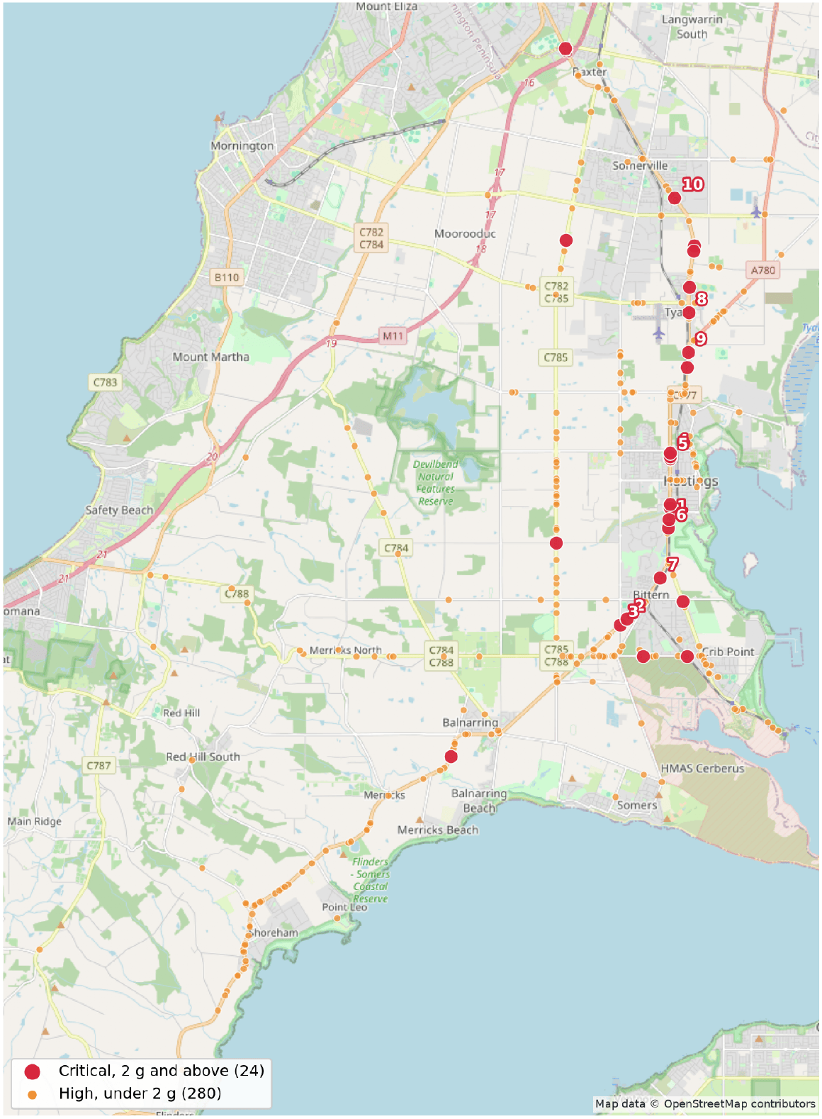
The MetaSpatial report records 1,120 km travelled over 45 drives, including repeat passes—not 1,120 km of unique roads. The 304 distinct defect sites comprise 24 rated critical and 280 rated high under the report’s classification.
What is the AI Pothole Patrol?
An RACV roadside-assistance van on the Mornington Peninsula is trialling RoughSense to identify road defects during routine journeys. The collaboration is featured in Australian Road Rider’s AI Pothole Patrol coverage.
MetaSpatial’s October report combines accelerometer impacts and driver-flagged potholes into a location-based road-condition record. Repeated observations are grouped into distinct sites, helping teams distinguish recurring problems from individual events.
FROM EVENTS TO EVIDENCE
See where attention is needed.
The report records 952 defect-grade events, grouped by location into 304 distinct sites. A site encountered on several drives is counted once, with its repeat observations retained.
21 of the 24 critical sites were recorded on two or more separate drives, building a stronger evidence base for follow-up inspection.
Critical denotes a recorded peak impact of 2 g or more. These are monitoring classifications, not a standalone engineering assessment of road safety.

MetaSpatial: connecting perception to decisions
MetaSpatial’s contribution includes sensing hardware, system implementation, field testing and data visualisation. RMIT leads the research, system integration, sensor-data fusion and AI road-defect detection; RACV facilitates and supports the vehicle trial.

That contribution sits within MetaSpatial’s wider technology offering: an integrated pathway from Echo perception and field-capture hardware to the Evolve Spatial Platform, helping infrastructure teams turn field observations into decisions at scale.
Capture
Collect road imagery, position and spatial evidence with Echo field systems.
Connect
Bring observations, survey history and asset context together in Evolve.
Act
Review AI-assisted findings, compare change and share controlled access with project teams.
Beyond the pilot: Echo MobileMapper supports mobile road and corridor capture, while Evolve provides a browser-based workspace for imagery, 3D data, measurements, analytics and traceable collaboration. These are MetaSpatial’s broader capabilities; individual deployments are configured to project requirements.
Supporting road dilapidation survey workflows
For construction and infrastructure projects, a road dilapidation survey establishes a condition baseline for comparison before and after works. Echo RoughSense adds repeat road-condition observations, while Echo MobileMapper supports detailed imagery and 3D corridor capture. Connected through Evolve, these records help teams review change and plan follow-up engineering inspections.
Why this matters for Melbourne and Victorian roads
Councils, road managers and infrastructure operators need evidence that is current, located and easy to review. Repeat monitoring can help teams investigate deterioration, prioritise inspections and plan maintenance with a clearer record of change—without relying on disconnected files and repeated handovers.